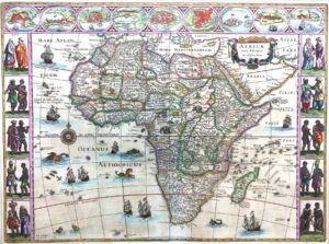
Rare Map of Africa by Dutch astronomer and cartographer Willem Blaeu, c. 1640.
Large, 35″x 24″ hand-colored Latin edition contains oval vignettes of major port cities bordering the top, with side borders showing costumed couples from various parts of the continent. Dutch slave ships ply their despicable trade off the coasts, while the ocean is populated with flying fish, whales, and “sea monsters.” The vast unexplored interior and nation-states are often fictionally depicted. By contrast, coastal regions, including the surprising number of rivers and tributaries, are more accurate and intricately portrayed than Ortelius’ 1570 map, shown previously.
By 1452, African slaves were growing a new crop, sugar cane, on Portugal’s European island of Madeira, and in 1493, Columbus himself brought the crop to Hispaniola (now Haiti and the Dominican Republic), which by 1516 was the largest producer in the New World. Brazil, a Portuguese colony since 1500, soon outpaced the others in sugar output, a commodity vying with Incan gold as a New World fount of wealth.
The Transatlantic Slave Trade multiplied tenfold after 1518, after Spain’s King Charles I (aka Charles V) authorized shipping captives directly from Africa instead of through Europe before coming to the Americas. Over the next century, Spain lost control of its eastern Caribbean possessions to France, England, and the Netherlands, nations that lay claim not only to its sugar crops, but coffee, tea, chocolate, and the spices which masked the off-taste of spoiling food.
As Portugal’s power also waned, the Dutch Navy and merchant fleet were ideally positioned to step into and retain its far-flung possessions and trading outposts across the globe. By the 1640s, the Netherlands had become the most important European trading power on the African coast. Between 1612 and 1872, the Dutch operated ten slave factories and fortresses along the Gold Coast (now Ghana), located near the center of the Western gulf coast and identified as “Guinea” (outlined in green at the Bight of Benin). Also known for its rich supply of gold, the region to its east, Wydah (now Benin), earned a new moniker, the “Slave Coast.”
After 1640, the evolution of European coffee houses and French pastry had confectioners crafting addicting delicacies that drastically increased sugar’s use. The demand for slaves skyrocketed as hundreds of West Indies sugar plantations consumed human beings as quickly as Continentals contracted diabetes and gout. The death rate for slaves had become twice that of births, but they were considered cheap and expendable, surviving on average seven years before succumbing to dangerous, labor-intensive growing fields or boiling houses, the lash, poor diet, mosquito-borne disease, or the climate itself.
Commodities available only to Europe’s elite were becoming commonplace. The ascension of a prosperous merchant class, its trading partners, and emergence of instruments of credit, debt, investment, accounting, and insurance fashioned during this period were formative in the rise of Capitalism. Ironically, this transformation to a free market economy depended largely upon slavery – and detailed maps such as Blaeu’s were vital to slavers negotiating the confused coastline of West Africa in locating fresh captives and re-provisioning stores before heading off to sugar producing destinations.


